| id |
675 |
| mdfileid_nerc_guid |
c95a735a-a506-32fa-e044-0003ba9b0d98
|
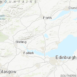
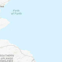
| cruise_area |
CP2 Regional Sea Boundaries: Northern North Sea, Offshore 1:250k: Borders, Tay-Forth, SeaVoX Sub-Ocean: NORTH SEA
|
| end_date |
1972-04-27 00:00:00
|
| abstract |
This British Geological Survey (BGS) marine sampling survey took place in April 1972 in the Firth of Forth on board the Wilma Russell. The purpose was to obtain data for regional geology mapping. Sea-bed samples were collected using a shipek grab. Sediment cores were collected using a gravity corer. These data are archived by BGS. Technical details of the survey are contained in report ?????.
|
| end_date_est |
Estimated
|
| cruise |
1972/20
|
| additional_info |
For more detailed information on the acquisition equipment and data collection techniques, operational standards, data processing methods and quality control procedures used on this survey see the Report of Survey/Cruise Report and associated documentation where available. The information available may vary depending on the age of the survey. Data are checked and loaded to the BGS Coastal and Marine data management system following BGS marine data management procedures.
|
| confidentiality |
unclassified (open file)
|
| cruise_alias |
None
|
| nav_equip_type |
Not Entered
|
| accessuse_restric |
unrestricted use, copyright acknowledgement
|
| restitle |
Sampling Survey 1972/20: Firth of Forth (21/Apr/1972 to 27/Apr/1972)
|
| geophys_equip_type |
None
|
| terms_of_use |
Available under the Open Government Licence subject to the following acknowledgement accompanying the reproduced British Geological Survey materials "Contains British Geological Survey materials ©UKRI [year]"
|
| ship |
Wilma Russell
|
| samp_equip_type |
Beach Sample, Corer: Sediment Gravity, Grab: Shipek
|
| terms_of_use_url |
http://nationalarchives.gov.uk/doc/open-government-licence/version/3/
|
| client |
British Geological Survey
|
| start_date |
1972-04-21 00:00:00
|
| contractor |
None
|
| start_date_est |
Estimated
|
| cruise_data_url |
None
|